Colorado Statewide Printed Maps. |
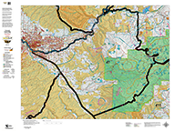
Statewide 1:500,000 BLM (Land Status) and 1:500,000 Shaded Relief Maps displaying the whole state with GMU boundary overlays. Great for hunting-based business or just conversation pieces in the den. The maps are 3' x 4' and are available on paper or canvas. Click on the plotter for more information!
Statewide GMU Maps including Private Land, BLM Lands,State Lands, National Forest, USGS Shaded Relief and more.
|
 | Colorado Hybrid Maps - Land Ownership OR Satellite with Concentrations. |
Hybrid Maps with a traditional Land Ownership or Satellite Base. We project summer, winter, resident herd and migration data on these base maps to create the best map available.
|
 | Colorado Elk Hunting Maps. |
Custom printed maps for every GMU West of I25! Choose between maps displaying land ownership (BLM), Elk Concentration (Elk), and basic topographical maps showing unit boundaries. All three maps are projected at 1:100,000 scale. For more about the different map scales, click Here for a brochure.
|
 | Colorado Mule Deer Hunting Maps. |
Custom Colorado Deer Hunting Maps with Game Management Unit boundaries with public and private land access as well as Deer Concentration information.
|
 | Colorado Antelope Hunting Maps. |
Custom Colorado Hunting Maps
|
 | Colorado Centerpoint Map - the most detailed custom map available. |
The most detailed custom map available. Give us you coordinates, a favorite mountain top, valley, or other location and we'll build the most detailed map available (7.5 minute) around your "Centerpoint". We can add concentration date, unit boundaries, private land shading covering an 12 by 12 mile area.
|
 | Colorado Bighorn Sheep. |
Land Ownership, Satellite, and Topo Maps for each Bighorn Sheep Unit. The Land Ownership and Satellite Maps display plotted kill sites and drainage areas with Summer and Winter Concentrations. The Topo series provides a traditional Topographical view of the unit. The maps are custom, built from the bottom up with current data. Each of the maps have a quick scan QR code to load the maps into your Smartphone!
|
 | Colorado Mountain Goat Unit Maps. |
Land Ownership, Satellite, and Topo Maps for each Mountain Goat Unit. The Land Ownership and Satellite Maps display plotted kill sites and drainage areas with Summer and Winter Concentrations. The Topo series provides a traditional Topographical view of the unit. The maps are custom, built from the bottom up with current data. All of the maps have a quick scan QR code to load the maps into your Smartphone!
|
 | Colorado Moose Unit Maps. |
Land Ownership, Satellite, and Topo Maps for each Moose Unit. The Land Ownership and Satellite Maps display plotted kill sites and drainage areas with Summer and Winter Concentrations. The Topo series provides a traditional Topographical view of the unit. The maps are custom, built from the bottom up with current data. All of the maps have a quick scan QR code to load the maps into your Smartphone!
|
 | Custom Colorado Whitetail Deer Hunting Maps - Eastern Plans. |
BLM Land Ownership Maps for every unit East of Interstate 25 with Whitetail Deer Concentrations highlighted.
|
BigGame CD. |
On Sale NOW! BigGameCD is a computer program with maps, statistics, and research about big game hunting in Colorado. An invaluable tool for hunters who want to improve their chances of success in the draw AND the field. Click Here for BigGameCD statistical features and click Here for an overview of the 1:500,000 maps included with BigGameCD.
|
Colorado Digital Map Set. |
Our popular Statewide Digital Map Sets ready for integration with BigGameCD 7.0 or view the maps in 3D using Google Earth or your iPhone or DROID (locates off satellites)! The map sets contain a Land Ownership Map, USGS Topographic Map, and Concentration Maps for Deer, Elk, and Antelope. For the Eastern Plains units (E of I25) we have the Land Ownership Maps, Turkey, Goose, Pheasant, Antelope, and White Tail Deer Concentration Maps. View them in 3D on Google Earth then load them to your iOS or DROID phone and hit the trail.
|
 | Colorado Turkey Habitat Maps. |
Turkey Concentration Maps for every Unit in Colorado. The maps display Roost Areas, Spring Concentrations, Winter Concentrations, and Overall Ranges. 1:100,000 Topo Map background. We'll show you Where to Hunt. As you check out, note there is an option for just the Digital Maps.
|
Colorado Statewide 'Where to Hunt'. |
The Where-to-Hunt Maps are Statewide Maps with Unit Overlays. The Units Boundaries are color coded indicating either draw or over-the-counter. On top of the boundaries, we then overlay the species data. For Turkey, we overlay Winter and Spring concentrations. For Archery and Muzzleloading, we add the Summer Ranges, Concentrations, and Resident Herds. For Over-the-Counter Rifle, we color code the units then add the migration routes, migration corridors, and winter concentration areas.
|
Colorado Wilderness Hunting Maps. |
1:100,000 Colorado Wilderness Maps with GMU boundaries for all intersected units and elk concentration areas - summer, winter, resident herds and migration routes.
|
 | Custom Colorado Bear Hunting Maps. |
Summer and Fall Bear Concentration Maps for all Big Game Units (GMU's).
|
Colorado Statewide Digital Maps. |
Our popular Statewide and Regional Map Sets ready for integration with BigGameCD 7.0 or view the maps in 3D using Google Earth! The map sets contain a Land Ownership Map, USGS Topographic Map, Nasa LandSat Image, and an Elk Concentration Map. Integrate the maps with BigGameCD 7.0, project overlays for all big game species then save or print the 1:100,000 scale maps. You do not have to own BigGameCD 7.0 to use the maps, use them independently in Google Earth! Click Here for a brochure describing the digital map products.
|
 | Custom Canada Goose Concentration Maps. |
BLM GMU (Game Management Unit) Land Ownership maps for all Units East of I25 with Snow Goose concentration (migration) data.
|
Custom Colorado Eastern Plains Maps. |
BLM Land Ownership Maps for Units East of Interstate I25
|