HuntData LLC
For Sales please Call.
303.663.4878
For support questions, please send us an email
the response will be much faster .
Home » Utah » All Products
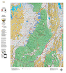
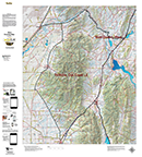
UT Elk Land Ownership Map.
Details
The Land Ownership Maps are built using land ownership data from USGS, National Forest and the State. We add current location data, streams, lakes, roads and trails from the USGS 7.5 minute Quad Map data set then print it on our rugged map fabric to create the best map in the industry. Click on the small map at left to see a larger sample. Scroll to the bottom of the map to order then move to the bottom right to Add To Cart.
Utah_Elk_Units: Please Select... UT Elk Book Cliffs (50 UTELOBCLF)
UT Elk Box Elder, Grouse Creek (51 UTELOBEGC)
UT Elk Box Elder, Hansel Mtn. (52 UTELOBEHM)
UT Elk Box Elder, Pilot-Mtn Nevada (53 UTELOBEPN)
UT Elk Beaver East (54 UTELOBEVE)
UT Elk Beaver West (55 UTELOBEVW)
UT Elk Bonanza_Vernal_Ystone_(East) (56 UTELOBVYE)
UT Elk Bonanza_Vernal_Ystone_(West) (57 UTELOBVYW)
UT Elk Cache, North (58 UTELOCCHN)
UT Elk Cache, South (59 UTELOCCHS)
UT Elk Cache, East Rich (60 UTELOCERC)
UT Elk Chalk Creek (61 UTELOCHCR)
UT Elk Central Mtns, Manti (62 UTELOCMMT)
UT Elk Central Mtns, Nebo (63 UTELOCMNE)
UT Elk East Canyon (64 UTELOECAN)
UT Elk Fillmore, Oak Creek (65 UTELOFILC)
UT Elk Fillmore, Pahvant (66 UTELOFLPT)
UT Elk Henry Mtns (67 UTELOHNMT)
UT Elk Kamas (68 UTELOKAM)
UT Elk La Sal, La Sal Mtns (69 UTELOLSAL)
UT Elk Monroe (70 UTELOMONR)
UT Elk Moran-South Rich (71 UTELOMSRC)
UT Elk Mt Dutton (72 UTELOMTDT)
UT Elk Nine Mile, Anthro (73 UTELONMAN)
UT Elk LO Nine Mile, Range Creek (74 UTELONMRC)
UT Elk LO North Slope, Three Corners (75 UTELONSTC)
UT Elk LO Ogden (76 UTELOOGDN)
UT Elk LO Oquirrh-Stansbury (77 UTELOOQST)
UT Elk LO Panguitch Lake (78 UTELOPALK)
UT Elk LO Paunsaugunt (79 UTELOPAUN)
UT Elk LO Plateau Boulder Kaiparowits (North) (80 UTELOPBKN)
UT Elk LO Plateau Boulder Kaiparowits (South) (81 UTELOPBKS)
UT Elk LO Plateau, Fishlake, Thousand Lakes (82 UTELOPFTL)
UT Elk LO Pine Valley (83 UTELOPNVA)
UT Elk LO San Juan Bull Elk (North) (84 UTELOSJBN)
UT Elk LO San Juan Bull Elk (South) (85 UTELOSJBS)
UT Elk LO San Juan, Montezuma Canyon (86 UTELOSJMC)
UT Elk LO San Rafael Dirty Devil (North) (87 UTELOSRDN)
UT Elk LO San Rafael Dirty Devil (South) (88 UTELOSRDS)
UT Elk LO San Rafael, North (89 UTELOSRFN)
UT Elk LO Southwest Desert (North) (90 UTELOSWDN)
UT Elk LO Southwest Desert (South) (91 UTELOSWDS)
UT Elk LO West Desert, Deep Creek (92 UTELOWDDC)
UT Elk LO West Desert, East (93 UTELOWDEA)
UT Elk LO Wasatch Mtns (94 UTELOWMTN)
UT Elk LO Wasatch Mtns, North (95 UTELOWMTNN)
UT Elk LO Zion (96 UTELOZION)
Price: $29.95
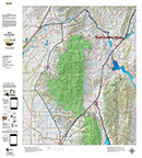
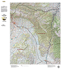
UT Mule Deer Habitat Unit Maps.
Details
We project Summer, Winter, and Fall Concentration data over a Topo base to create an informative and colorful concentration map. Click on the small map at left to see a larger sample. Scroll to the bottom of the map to order then move to the bottom right to Add To Cart. The maps are designed to help you determine where you SHOULD be hunting in your unit during your season. These maps are built on the USGS 1:100,000 base Topo series with enhanced Lakes, Roads and Trails from the USGS 7.5 minute Quad Maps. This map should be part of your hunting tool kit!
Utah_Deer_Units: Please Select... UT Deer Antelope Island 01_UTDLOANIS
UT Deer Book Cliffs 02_UTDLOBCLF
UT Deer Beaver 03_UTDLOBEAV
UT Deer Box Elder 04_UTDLOBELD
UT Deer Cache 05_UTDLOCACH
UT Deer Cache, Crawford Mtn. 06_UTDLOCCMT
UT Deer Chalk Creek, East Canyon, Morgan-South Rich
UT Deer Central Mtns, Manti, San Rafael 08_UTDLOCMMS
UT Deer Central Mtns, Nebo 09_UTDLOCMNE
UT Deer Central Mtns, San Rafael (Central) 10_UTDLOCSRC
UT Deer Central Mtns, San Rafael (North) 11_UTDLOCSRN
UT Deer Central Mtns, San Rafael (South) 12_UTDLOCSRS
UT Deer Fillmore 13_UTDLOFMOR
UT Deer Fillmore, Oak Creek LE 14_UTDLOFOLE
UT Deer Henry Mtns. 15_UTDLOHNMT
UT Deer Kamas 16_UTDLOKAMA
UT Deer Fillmore, Oak Creek LE 14_UTDLOFOLE
UT Deer Henry Mtns. 15_UTDLOHNMT
UT Deer Kamas 16_UTDLOKAMA
UT Deer La Sal, Dolores Triangle 17_UTDLOLSDT
UT Deer La Sal, La Sal Mtns. 18_UTDLOLSMT
UT Deer Monroe 19_UTDLOMONR
UT Deer Mt Dutton 20_UTDLOMTDU
UT Deer Nine Mile (N) 21_UTDLONMIN
UT Deer Nine Mile (S) 22_UTDLONMIS
UT Deer North Slope 23_UTDLONSLO
UT Deer North Slope (Summit) 24_UTDLONSSM
UT Deer Ogden 25_UTDLOOGDN
UT Deer Oquirrh-Stansbury 26_UTDLOOSBY
UT Deer Panguitch Lake 27_UTDLOPALK
UT Deer Paunsaugunt 28_UTDLOPAUN
UT Deer Plateau, Boulder Kaiparowits (N) 29_UTDLOPBKN
UT Deer Plateau, Boulder Kaiparowits (S) 30_UTDLOPBKS
UT Deer Pleateu, Fishlake 31_UTDLOPFSH
UT Deer Plateau, Thousand Lakes 32_UTDLOPTHL
UT Deer Pine Valley 33_UTDLOPVAL
UT Deer San Juan, Abajo Mtns. 34_UTDLOSJAM
UT Deer San Juan, Elk Ridge 35_UTDLOSJER
UT Deer South Slope, Bonanza Vernal 36_UTDLOSSBV
UT Deer South Slope, Diamond Mtn. 37_UTDLOSSDM
UT Deer South Slope, Yellowstone 38_UTDLOSSYL
UT Deer Southwest Desert (N) 39_UTDLOSWDN
UT Deer Southwest Desert (S) 40_UTDLOSWDS
UT Deer West Desert (N) 41_UTDLOWDN
UT Deer West Desert (S) 42_UTDLOWDS
UT Deer West Desert, Tintic 43_UTDLOWDT
UT Deer West Desert Vernon 44_UTDLOWDV
UT Deer Wasatch Mtns, East 45_UTDLOWME
UT Deer Wasatch Mtns, West 46_UTDLOWMW
UT Deer Zion 47_UTDLOZION
Price: $29.95
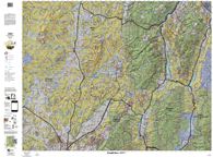
Hybrid! Mule Deer Land Ownership AND habitat on one map.
Details
Our Hybrid Maps are built with land ownership data then we project Summer, Fall, and Winter Concentration data to create a map showing you not only where you CAN hunt, but where you SHOULD hunt as well! Click on the small map at left to see a larger sample then Scroll to the bottom of the map to order then move to the bottom right to Add To Cart.We also add the USGS roads and trails from their 7.5minute Quad Maps. We use 5 different software programs to handle the complexity and publication of these maps. The Hybrid maps are printed on our rugged map fabric to create a map that will last as long as your memories!
Utah_Deer_Units_Hybrid: Please Select... UT Deer LO Antelope Island 01_UTDLOANIS
UT Deer LO Book Cliffs 02_UTDLOBCLF
UT Deer LO Beaver 03_UTDLOBEAV
UT Deer LO Box Elder 04_UTDLOBELD
UT Deer LO Cache 05_UTDLOCACH
UT Deer LO Cache, Crawford Mtn. 06_UTDLOCCMT
UT Deer LO Chalk Creek, East Canyon, Morgan-South Rich
UT Deer LO Central Mtns, Manti, San Rafael 08_UTDLOCMMS
UT Deer LO Central Mtns, Nebo 09_UTDLOCMNE
UT Deer LO Central Mtns, San Rafael (Central) 10_UTDLOCSRC
UT Deer LO Central Mtns, San Rafael (North) 11_UTDLOCSRN
UT Deer LO Central Mtns, San Rafael (South) 12_UTDLOCSRS
UT Deer LO Fillmore 13_UTDLOFMOR
UT Deer LO Fillmore, Oak Creek LE 14_UTDLOFOLE
UT Deer LO Henry Mtns. 15_UTDLOHNMT
UT Deer LO Kamas 16_UTDLOKAMA
UT Deer LO Fillmore, Oak Creek LE 14_UTDLOFOLE
UT Deer LO Henry Mtns. 15_UTDLOHNMT
UT Deer LO Kamas 16_UTDLOKAMA
UT Deer LO La Sal, Dolores Triangle 17_UTDLOLSDT
UT Deer LO La Sal, La Sal Mtns. 18_UTDLOLSMT
UT Deer LO Monroe 19_UTDLOMONR
UT Deer LO Mt Dutton 20_UTDLOMTDU
UT Deer LO Nine Mile (N) 21_UTDLONMIN
UT Deer LO Nine Mile (S) 22_UTDLONMIS
UT Deer LO North Slope 23_UTDLONSLO
UT Deer LO North Slope (Summit) 24_UTDLONSSM
UT Deer LO Ogden 25_UTDLOOGDN
UT Deer LO Oquirrh-Stansbury 26_UTDLOOSBY
UT Deer LO Panguitch Lake 27_UTDLOPALK
UT Deer LO Paunsaugunt 28_UTDLOPAUN
UT Deer LO Plateau, Boulder Kaiparowits (N) 29_UTDLOPBKN
UT Deer LO Plateau, Boulder Kaiparowits (S) 30_UTDLOPBKS
UT Deer LO Pleateu, Fishlake 31_UTDLOPFSH
UT Deer LO Plateau, Thousand Lakes 32_UTDLOPTHL
UT Deer LO Pine Valley 33_UTDLOPVAL
UT Deer LO San Juan, Abajo Mtns. 34_UTDLOSJAM
UT Deer LO San Juan, Elk Ridge 35_UTDLOSJER
UT Deer LO South Slope, Bonanza Vernal 36_UTDLOSSBV
UT Deer LO South Slope, Diamond Mtn. 37_UTDLOSSDM
UT Deer LO South Slope, Yellowstone 38_UTDLOSSYL
UT Deer LO Southwest Desert (N) 39_UTDLOSWDN
UT Deer LO Southwest Desert (S) 40_UTDLOSWDS
UT Deer LO West Desert (N) 41_UTDLOWDN
UT Deer LO West Desert (S) 42_UTDLOWDS
UT Deer LO West Desert, Tintic 43_UTDLOWDT
UT Deer LO West Desert Vernon 44_UTDLOWDV
UT Deer LO Wasatch Mtns, East 45_UTDLOWME
UT Deer LO Wasatch Mtns, West 46_UTDLOWMW
UT Deer LO Zion 47_UTDLOZION
Price: $39.95
UT Mule Deer Land Ownership Unit Maps.
Details
The Land Ownership Maps are built using land ownership data from USGS, National Forest and the State. We add current location data, streams, lakes, roads and trails from the USGS 7.5 minute Quad Map data set then print it on our rugged map fabric to create the best map in the industry. Click on the small map at left to see a larger sample. Scroll to the bottom of the map to order then move to the bottom right to Add To Cart.
Utah_Deer_Units: Please Select... UT Deer Antelope Island 01_UTDLOANIS
UT Deer Book Cliffs 02_UTDLOBCLF
UT Deer Beaver 03_UTDLOBEAV
UT Deer Box Elder 04_UTDLOBELD
UT Deer Cache 05_UTDLOCACH
UT Deer Cache, Crawford Mtn. 06_UTDLOCCMT
UT Deer Chalk Creek, East Canyon, Morgan-South Rich
UT Deer Central Mtns, Manti, San Rafael 08_UTDLOCMMS
UT Deer Central Mtns, Nebo 09_UTDLOCMNE
UT Deer Central Mtns, San Rafael (Central) 10_UTDLOCSRC
UT Deer Central Mtns, San Rafael (North) 11_UTDLOCSRN
UT Deer Central Mtns, San Rafael (South) 12_UTDLOCSRS
UT Deer Fillmore 13_UTDLOFMOR
UT Deer Fillmore, Oak Creek LE 14_UTDLOFOLE
UT Deer Henry Mtns. 15_UTDLOHNMT
UT Deer Kamas 16_UTDLOKAMA
UT Deer Fillmore, Oak Creek LE 14_UTDLOFOLE
UT Deer Henry Mtns. 15_UTDLOHNMT
UT Deer Kamas 16_UTDLOKAMA
UT Deer La Sal, Dolores Triangle 17_UTDLOLSDT
UT Deer La Sal, La Sal Mtns. 18_UTDLOLSMT
UT Deer Monroe 19_UTDLOMONR
UT Deer Mt Dutton 20_UTDLOMTDU
UT Deer Nine Mile (N) 21_UTDLONMIN
UT Deer Nine Mile (S) 22_UTDLONMIS
UT Deer North Slope 23_UTDLONSLO
UT Deer North Slope (Summit) 24_UTDLONSSM
UT Deer Ogden 25_UTDLOOGDN
UT Deer Oquirrh-Stansbury 26_UTDLOOSBY
UT Deer Panguitch Lake 27_UTDLOPALK
UT Deer Paunsaugunt 28_UTDLOPAUN
UT Deer Plateau, Boulder Kaiparowits (N) 29_UTDLOPBKN
UT Deer Plateau, Boulder Kaiparowits (S) 30_UTDLOPBKS
UT Deer Pleateu, Fishlake 31_UTDLOPFSH
UT Deer Plateau, Thousand Lakes 32_UTDLOPTHL
UT Deer Pine Valley 33_UTDLOPVAL
UT Deer San Juan, Abajo Mtns. 34_UTDLOSJAM
UT Deer San Juan, Elk Ridge 35_UTDLOSJER
UT Deer South Slope, Bonanza Vernal 36_UTDLOSSBV
UT Deer South Slope, Diamond Mtn. 37_UTDLOSSDM
UT Deer South Slope, Yellowstone 38_UTDLOSSYL
UT Deer Southwest Desert (N) 39_UTDLOSWDN
UT Deer Southwest Desert (S) 40_UTDLOSWDS
UT Deer West Desert (N) 41_UTDLOWDN
UT Deer West Desert (S) 42_UTDLOWDS
UT Deer West Desert, Tintic 43_UTDLOWDT
UT Deer West Desert Vernon 44_UTDLOWDV
UT Deer Wasatch Mtns, East 45_UTDLOWME
UT Deer Wasatch Mtns, West 46_UTDLOWMW
UT Deer Zion 47_UTDLOZION
Price: $29.95
4 Map Combo, Save $20.
Details
Get all 4 great maps, Land Ownership, Habitat, Satellite and Topo. The first 3 are printed on our rugged map fabric. The Topo map is printed on our tear and water resistant paper. The ultimate pack of maps for your hunt.
Utah_Deer_Units: Please Select... UT Deer Antelope Island 01_UTDLOANIS
UT Deer Book Cliffs 02_UTDLOBCLF
UT Deer Beaver 03_UTDLOBEAV
UT Deer Box Elder 04_UTDLOBELD
UT Deer Cache 05_UTDLOCACH
UT Deer Cache, Crawford Mtn. 06_UTDLOCCMT
UT Deer Chalk Creek, East Canyon, Morgan-South Rich
UT Deer Central Mtns, Manti, San Rafael 08_UTDLOCMMS
UT Deer Central Mtns, Nebo 09_UTDLOCMNE
UT Deer Central Mtns, San Rafael (Central) 10_UTDLOCSRC
UT Deer Central Mtns, San Rafael (North) 11_UTDLOCSRN
UT Deer Central Mtns, San Rafael (South) 12_UTDLOCSRS
UT Deer Fillmore 13_UTDLOFMOR
UT Deer Fillmore, Oak Creek LE 14_UTDLOFOLE
UT Deer Henry Mtns. 15_UTDLOHNMT
UT Deer Kamas 16_UTDLOKAMA
UT Deer Fillmore, Oak Creek LE 14_UTDLOFOLE
UT Deer Henry Mtns. 15_UTDLOHNMT
UT Deer Kamas 16_UTDLOKAMA
UT Deer La Sal, Dolores Triangle 17_UTDLOLSDT
UT Deer La Sal, La Sal Mtns. 18_UTDLOLSMT
UT Deer Monroe 19_UTDLOMONR
UT Deer Mt Dutton 20_UTDLOMTDU
UT Deer Nine Mile (N) 21_UTDLONMIN
UT Deer Nine Mile (S) 22_UTDLONMIS
UT Deer North Slope 23_UTDLONSLO
UT Deer North Slope (Summit) 24_UTDLONSSM
UT Deer Ogden 25_UTDLOOGDN
UT Deer Oquirrh-Stansbury 26_UTDLOOSBY
UT Deer Panguitch Lake 27_UTDLOPALK
UT Deer Paunsaugunt 28_UTDLOPAUN
UT Deer Plateau, Boulder Kaiparowits (N) 29_UTDLOPBKN
UT Deer Plateau, Boulder Kaiparowits (S) 30_UTDLOPBKS
UT Deer Pleateu, Fishlake 31_UTDLOPFSH
UT Deer Plateau, Thousand Lakes 32_UTDLOPTHL
UT Deer Pine Valley 33_UTDLOPVAL
UT Deer San Juan, Abajo Mtns. 34_UTDLOSJAM
UT Deer San Juan, Elk Ridge 35_UTDLOSJER
UT Deer South Slope, Bonanza Vernal 36_UTDLOSSBV
UT Deer South Slope, Diamond Mtn. 37_UTDLOSSDM
UT Deer South Slope, Yellowstone 38_UTDLOSSYL
UT Deer Southwest Desert (N) 39_UTDLOSWDN
UT Deer Southwest Desert (S) 40_UTDLOSWDS
UT Deer West Desert (N) 41_UTDLOWDN
UT Deer West Desert (S) 42_UTDLOWDS
UT Deer West Desert, Tintic 43_UTDLOWDT
UT Deer West Desert Vernon 44_UTDLOWDV
UT Deer Wasatch Mtns, East 45_UTDLOWME
UT Deer Wasatch Mtns, West 46_UTDLOWMW
UT Deer Zion 47_UTDLOZION
Price: $99.95
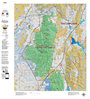
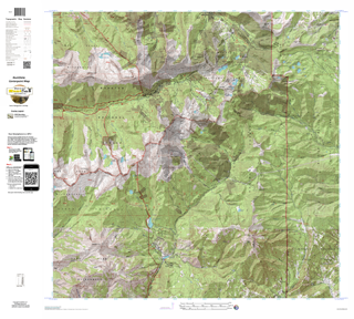
UT Mule Deer Topo Unit Map.
Details
We redesigned our Topo series this year adding updated roads from the USGS 7.5 minute map series to the 1:100, 000 Topo base. Click on the small map at left to see a larger sample. Scroll to the bottom of the map to order then move to the bottom right to Add To Cart. We also enhanced the Forest Service boundries. The result is a traditional topo map with current info! A great tool for your hunt.
Utah_Deer_Units: Please Select... UT Deer Antelope Island 01_UTDLOANIS
UT Deer Book Cliffs 02_UTDLOBCLF
UT Deer Beaver 03_UTDLOBEAV
UT Deer Box Elder 04_UTDLOBELD
UT Deer Cache 05_UTDLOCACH
UT Deer Cache, Crawford Mtn. 06_UTDLOCCMT
UT Deer Chalk Creek, East Canyon, Morgan-South Rich
UT Deer Central Mtns, Manti, San Rafael 08_UTDLOCMMS
UT Deer Central Mtns, Nebo 09_UTDLOCMNE
UT Deer Central Mtns, San Rafael (Central) 10_UTDLOCSRC
UT Deer Central Mtns, San Rafael (North) 11_UTDLOCSRN
UT Deer Central Mtns, San Rafael (South) 12_UTDLOCSRS
UT Deer Fillmore 13_UTDLOFMOR
UT Deer Fillmore, Oak Creek LE 14_UTDLOFOLE
UT Deer Henry Mtns. 15_UTDLOHNMT
UT Deer Kamas 16_UTDLOKAMA
UT Deer Fillmore, Oak Creek LE 14_UTDLOFOLE
UT Deer Henry Mtns. 15_UTDLOHNMT
UT Deer Kamas 16_UTDLOKAMA
UT Deer La Sal, Dolores Triangle 17_UTDLOLSDT
UT Deer La Sal, La Sal Mtns. 18_UTDLOLSMT
UT Deer Monroe 19_UTDLOMONR
UT Deer Mt Dutton 20_UTDLOMTDU
UT Deer Nine Mile (N) 21_UTDLONMIN
UT Deer Nine Mile (S) 22_UTDLONMIS
UT Deer North Slope 23_UTDLONSLO
UT Deer North Slope (Summit) 24_UTDLONSSM
UT Deer Ogden 25_UTDLOOGDN
UT Deer Oquirrh-Stansbury 26_UTDLOOSBY
UT Deer Panguitch Lake 27_UTDLOPALK
UT Deer Paunsaugunt 28_UTDLOPAUN
UT Deer Plateau, Boulder Kaiparowits (N) 29_UTDLOPBKN
UT Deer Plateau, Boulder Kaiparowits (S) 30_UTDLOPBKS
UT Deer Pleateu, Fishlake 31_UTDLOPFSH
UT Deer Plateau, Thousand Lakes 32_UTDLOPTHL
UT Deer Pine Valley 33_UTDLOPVAL
UT Deer San Juan, Abajo Mtns. 34_UTDLOSJAM
UT Deer San Juan, Elk Ridge 35_UTDLOSJER
UT Deer South Slope, Bonanza Vernal 36_UTDLOSSBV
UT Deer South Slope, Diamond Mtn. 37_UTDLOSSDM
UT Deer South Slope, Yellowstone 38_UTDLOSSYL
UT Deer Southwest Desert (N) 39_UTDLOSWDN
UT Deer Southwest Desert (S) 40_UTDLOSWDS
UT Deer West Desert (N) 41_UTDLOWDN
UT Deer West Desert (S) 42_UTDLOWDS
UT Deer West Desert, Tintic 43_UTDLOWDT
UT Deer West Desert Vernon 44_UTDLOWDV
UT Deer Wasatch Mtns, East 45_UTDLOWME
UT Deer Wasatch Mtns, West 46_UTDLOWMW
UT Deer Zion 47_UTDLOZION
Price: $24.95
UT Antelope Topo Unit Map.
Details
We redesigned our Topo series this year adding updated roads from the USGS 7.5 minute map series to the 1:100, 000 Topo base. Click on the small map at left to see a larger sample. Scroll to the bottom of the map to order then move to the bottom right to Add To Cart. We also enhanced the Forest Service boundries. The result is a traditional topo map with current info! A great tool for your hunt.
Utah Antelope Units: Please Select... Beaver
Book Cliffs, Bitter Creek
Book Cliffs, South
Box Elder, Promotory
Box Elder, Pubble Valley
Box Elder, Snowville
Box Elder, West
Cache Morgan, S Rich, Ogden
Fillmore, Oak Creek S
Kaiprarowits
La Sal, Potash, S Cisco
Mt Dutton, Paunsaugunt
Nine Mile, Antro-Myton Bench
Nine Mile, Range Creek
North Slope, Summit
North Slope, Three Corners, West Dagget
Panguitch Lake, Zion, N
Pine Valley
Plateau, Parker Mtn
San Juan, Hatch Point
San Rafael, Desert
San rafael, North
S Slope Bonanza Diamond Mtn
S Slope Vernal
SW Desert
W Desert, Riverbed
W Desert, Rush Valley
W Desert, Snake Valley
Price: $24.95
Utah_Centerpoint.
Details
The most detailed custom map available. Give us you coordinates or location, and we'll build a 7.5 minute 12 mile by 12 mile map around your Centerpoint. The map will be printed on our rugged fabric to last as long as your memories!
Enter your Utah Coordinates: Centerpoint_Base_Map: Please Select... Printed Topographical 12x12 Miles (+$49.95)
Printed Satellite 8x8 Miles (+$49.95)
Printed Topo 12x12 mi with Digital Smartphone Image (Avenza Maps Scannable QR Code) (+$69.95)
Printed Satellite 8x8 mi with Digital Smartphone Image (Avenza Maps Scannable QR Code) (+$69.95)
Enter Unit and Other Comments:
Price: $0.00
« Previous | 1 | 2 | 3 | Next »
Note: If you are unable to add items to your cart please make sure you are able to accept
Session "cookies" in your browser.
home |
about us |
products | search | checkout
| e-mail
| privacy policy
HuntData Copyright 1996-2008 HuntData LLC.
Web site Optimization and Design By fmtmwebservices.net
& Uswebtek.com